 कोयंबटूर में 77वें स्वतंत्रता दिवस 11 मीटर ऊंचा स्टील टावर पर घुमावदार एलईडी स्क्रीन
  Elvish Yadav wins Bigg Boss OTT season 2, fans erupt in joy
  Glimpses from 77th Independence Day at Red Fort in Delhi
  सीएम योगी ने 77वें स्वतंत्र दिवस पर किया ध्वजारोहण
  Happy 77th Independence Day
  President raises climate change concerns in I-Day eve speech
  Next year, on August 15 from Red Fort: PM Modi’s big remark on 2024
  ‘Bharat Mata is voice of every Indian’: Rahul extends wish on Independence Day
  “Selfishness of few pushed nation to tragedy of Partition”: CM Yogi Adityanath
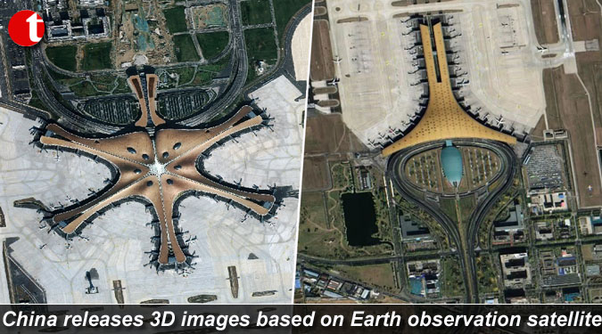
TIL Desk/World/Beijing/ The China National Space Administration on Tuesday released the first batch of 3D images based on the data from the recently launched Gaofen-7 Earth observation satellite.
The Gaofen-7, an important part of China”s high-definition Earth observation project, is the country”s first civil-use optical transmission three-dimensional surveying and mapping satellite that reaches the sub-meter definition.
The 22 images show the Beijing Capital International Airport, the new Beijing Daxing International Airport, as well as some regions in China”s Anhui, Guangdong and Shandong provinces. Airplanes, vehicles, buildings and trees can be clearly seen in the images.
The satellite, launched from the Taiyuan Satellite Launch Centre in Shanxi province on November 3, is in orbit at an altitude of 506 km and has a design life of eight years. More than 14,000 images have been obtained by the satellite.
Related Posts